Map of Preston city centre: how the streets and the landmarks sit
A schematic and a description, for working out where things are in relation to each other before you set out.
Central Preston is small enough to cross on foot in twenty minutes and shaped by one thing that a street plan does not show: the ground falls away sharply on the south side. Everything else follows from that. The commercial centre sits on the level ground at the top of the slope, the two Victorian parks occupy the slope itself, and the river runs along the bottom. Knowing which of those three levels you are on tells you most of what you need.
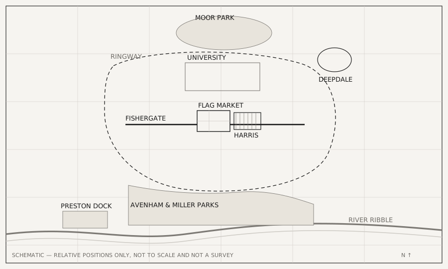
The centre, and the one square everything is measured from
The Flag Market is the reference point. It is the open square in front of the Harris Museum and Art Gallery, and it is where the civic buildings, the market ground and the shopping streets meet. If a Preston address is described as central, it is usually within a few minutes of it.
From the Flag Market, Fishergate runs west as the main shopping street and Miller Arcade sits immediately east. That single line — square, arcade, high street — is the spine of the centre, and almost everything a visitor is looking for is either on it or one street off it.
South: the slope, the parks and the river
Walk south from the centre and the ground drops. Avenham and Miller Parks occupy that fall, running down to the Ribble. This is the part of the layout people underestimate from a flat map: the parks are not a detour from the centre, they begin at the edge of it, and the walk down is a few minutes as opposed to a trip. Further west along the same river bank is Preston Dock.
North: the university, and the park beyond it
North of the shopping streets the centre runs into the university with no clear boundary on the pavement, which is why the northern half of the centre feels different on a weekday. Beyond the campus is Moor Park, the widest flat open ground in the city, and a short walk north east of the centre is Deepdale.
The Ringway, and what counts as walkable
Why the shape is the way it is
The layout is not an accident of planning; it follows the ground. A market square needs level land, and the only level land close to the river crossing is the shelf the centre stands on. The slope below it was too steep to build on and became parkland, which is why Preston has designed Victorian landscape starting at the edge of its shopping streets instead of out on a suburb. The docks went where the river was navigable, west along the bank.
That order — ground first, then use — is also why the walk between two places is often shorter than a map suggests but steeper than expected. Distances in the centre are small; the gradient is the part that surprises people, and it runs in one direction only.
The inner ring road encloses the centre, and it is a useful mental boundary: inside it is the walkable core, outside it the city becomes residential streets, mills and estates. The retail parks, the hospital and most of the housing sit beyond it. That is also why the regeneration schemes cluster where they do — there is no large cleared site inside the ring, so change here means reusing buildings as opposed to filling gaps.
Where a printed map is still the better tool
This page gives relative positions, not distances, and there is a limit to what a schematic can carry: it will not give you a bus stop, a one-way system or a step-free route. For those the city council and the transport operators publish current maps, and they are the place to look because they change. What holds still is the shape described above — the three levels, the spine, and the ring — and that is what makes the rest legible.
Questions about Map of Preston city centre
Where is the centre of Preston?
The Flag Market, the open square in front of the Harris Museum and Art Gallery. The civic buildings, the market ground and the shopping streets all meet there.
How big is Preston city centre?
Small enough to cross on foot in about twenty minutes. The walkable core is the area inside the inner ring road; beyond it the city becomes residential streets and estates.
How do I get from the city centre to the parks?
Walk south. The ground falls away at the edge of the centre and Avenham and Miller Parks occupy that slope, running down to the River Ribble. It is a few minutes as opposed to a trip.